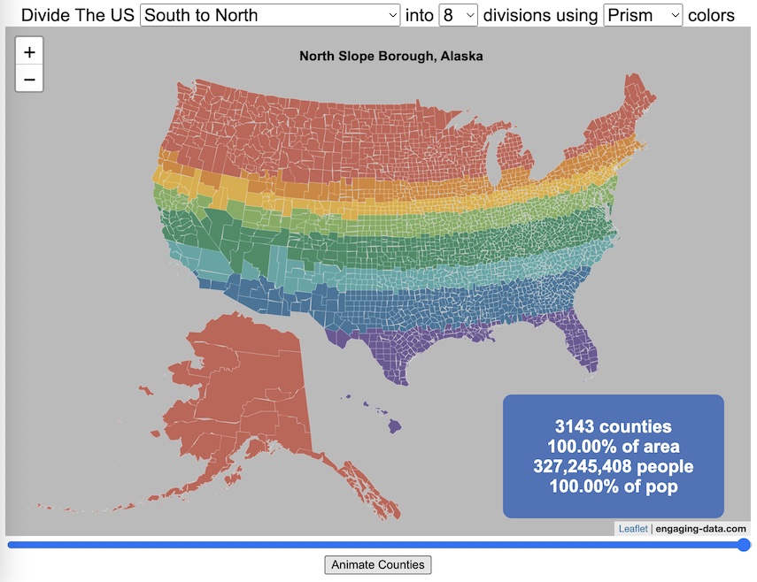
This visualization lets you divide the US into 1,2,3,4,5,8 and 10 different segments with equal population and across different dimensions. The divisions are made using counties as the building blocks (of which there are 3143 in the US). There are numerous different ways to make the divisions. This lets you make the divisions by different types of geographic directions and divisions by population density.
Instructions
- Select a dimension on which to divide up the country – there are geographic dimensions, like north to south or east to west, or by population density
- For some geographic divisions (concentric rings or pie slices), you can choose the geographic center of the divisions
- You can also choose the number and color scheme of the divisions
- To show the divisions, either click the Animate Counties button or use the slider to add counties
If you can think of other interesting ways to divide up the US, please let me know and I can try to add them to this visualization.
Sources and Tools:
2018 county population data is from US Census Bureau. The map visualization is created using the Leaflet javascript mapping library and the data wrangling and user interface and interactivity are created using HTML, CSS and Javascript code.
3 Comments »
3 Responses to Splitting the US by Population
This is really cool. Is there any way to lay major city names over the maps?
This is really fun and I learned a lot too. I kind of knew the Mercator projection wasn’t accurate, but had no idea it was so wildly off. County-wide populations are usually shown in a limited format, by state at the largest, but here it is easy to see how empty most of the country is vs. the huge numbers in coastal cities. Thank you for putting in all the work to create this, you made my night.
Now I’ve seen population dis-aggregated by counties, by latitude, by longitude — how about altitude?