Posts for Tag: voronoi
National Park Service Voronoi Map

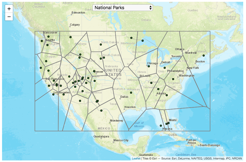
This map divides up the Continental United States into different regions depending on which National Park (or other National Park Service site) is closest to it. It is based on a straight-line (‘as the crow flies’) distance between locations rather than along road networks. It is an example of a Voronoi Diagram, which is subdivided into different regions based upon the distance between points of interest. Everything within a subregion is closer to the point defining the region than any other point.
Hover over the circle points to see the name of the park. The map has a dropdown menu that lets you choose between the following types of locations in the National Park Service:
- National Parks
- National Historic Sites
- National Memorial Sites
- National Monuments
- National Seashores/Lakeshores
- National Recreation Areas
- National Battlefields
- National Military Sites
- National Scenic Areas
For National Parks, there is a high concentration of National Parks in the Western US, especially around the Southwestern US and running up the Pacific Coast. As a result, in these areas, the Voronoi regions are fairly small. The Southwest is also home to a high concentration of National Monuments. There are only few parks in the Eastern US and so the Voronoi regions are correspondingly large. Looking at National Historic Sites, the situation is flipped somewhat, with a high concentration of historic sites in the eastern US, and specifically the Northeast.
Let me know in the comments which park you are closest to and which park you last visited.
Tools and Data Sources
Locations of each of the National Park Service sites comes from the National Park Service. The map was created using the Leaflet javascript mapping library and the Voronoi diagram using the Turfjs javascript, geospatial analysis library.
National Park Service Voronoi Map
This map divides up the Continental United States into different regions depending on which National Park (or other National Park Service site) is closest to it. It is based on a straight-line (‘as the crow flies’) distance between locations rather than along road networks. It is an example of a Voronoi Diagram, which is subdivided into different regions based upon the distance between points of interest. Everything within a subregion is closer to the point defining the region than any other point.
Hover over the circle points to see the name of the park. The map has a dropdown menu that lets you choose between the following types of locations in the National Park Service:
- National Parks
- National Historic Sites
- National Memorial Sites
- National Monuments
- National Seashores/Lakeshores
- National Recreation Areas
- National Battlefields
- National Military Sites
- National Scenic Areas
For National Parks, there is a high concentration of National Parks in the Western US, especially around the Southwestern US and running up the Pacific Coast. As a result, in these areas, the Voronoi regions are fairly small. The Southwest is also home to a high concentration of National Monuments. There are only few parks in the Eastern US and so the Voronoi regions are correspondingly large. Looking at National Historic Sites, the situation is flipped somewhat, with a high concentration of historic sites in the eastern US, and specifically the Northeast.
Let me know in the comments which park you are closest to and which park you last visited.
Tools and Data Sources
Locations of each of the National Park Service sites comes from the National Park Service. The map was created using the Leaflet javascript mapping library and the Voronoi diagram using the Turfjs javascript, geospatial analysis library.
Recent Comments